Saturday 20 December 2014

Day 5 - Sallent to Sandinies

From Punta del Pacino - looking over the valley to where we walked 2
days ago
This was another great day of walking. It felt a bit wilder than the other walks we had done this week. I'm not sure why. It was another long day, 18km and 1000m of ascent, not insignificant after such a massive day the day before. We had seen the first part of this day when we were coming in from Panticosa. So we knew we were going pretty sharply up through a forest at the start, before the first ascent of the day. This one was really quite easy, probably the easiest ascent of the week. It just came after a really long slog to the saddle.
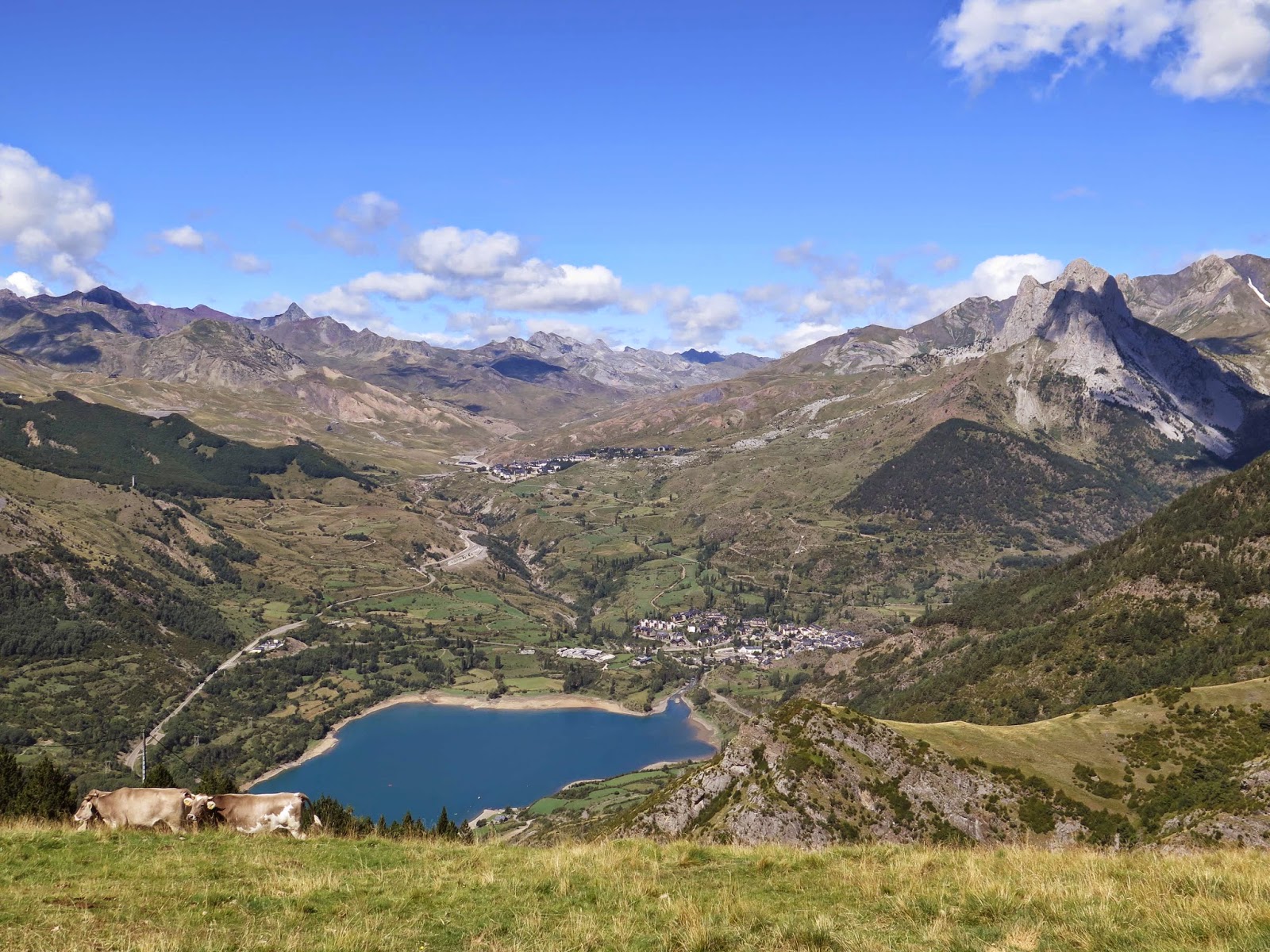
Looking towards we we walked yesterday - up the valley in the middle
After the final ascent of the day - happy to be on flat ground
We started at about 1200m in Panticosa and then had to get up to 1800m in just a couple of kilometres, so a pretty steep start. The views from the top were definitely worth it though. We could see back to where we had been walking both yesterday and the day before that. It's always slightly satisfying to see the mountains and ridges you have scaled before to get some idea of just how hard it looks from a distance. And let me tell you, it didn't look easy. The first ascent was 1965m, it was steep at the start, but overall nothing challenging. It was then a bit of a descent to a lake and yet another dam, not sure why there are so many dams. It's also strange to think that the state we were in, Aragon, is meant to be known for it's drought, and yet we had just spent a week constantly surrounded by lakes, dams and rivers. Perhaps that's why the rest of the state is so dry, they aren't letting the water flow south to it.

Yet another dam - surrounded by great mountains
Crossing the dam we came across a couple of mountain bikers. One of them was a young girl of about 10, it's nice to see adults getting their kids out, especially into such challenging terrain. I mean parts of this walk were just made for bikes, but it was pretty steep. And this section where we passed them was a bit of a cliff face, so they had to really just carry their bikes up it. Still if this was Australia I imagine the cyclists would have been completely banned from this trail, so it was nice to see that's not the case in the rest of the world, ie cyclists aren't a hunted species everywhere.

The view towards the dam, the second ascent is to the left in the mid-ground.
The one that just looks like a rocky outcrop - we climbed that. 
After lunching in the shade of an abandoned house it was up to another saddle. This abandoned house was pretty weird, it was completely burnt out, but nothing else was burnt around it, and it was miles from civilisation, at the very end of a dirt road with nothing around it. It made me wonder who would live there and what caused the fire. Perhaps it was an insurance scam, maybe it got to them after awhile, living so far from everything, but who else is going to want to buy the place.

Looking down from halfway up the climb - there is a
path of sorts in there, but it's a long fall if you slipped
The next section of the walk was pretty tricky, there was no path, we could see very clearly where we wanted to go, it's just that this section of the ground was full of steep gullies and ridges which would lead to a dead end - where you either had to go down and up a very steep gully, or turn around and try to find another way through. It was a very strange little section. After navigating it we made it up to another saddle, where we could head up Punta de la Cochata. I have to say I wasn't that keen to head up, it was incredibly steep. It looked almost like a cliff. It wasn't very long, thankfully, but I just didn't want to end up stuck halfway up not being able to go further up or getting down.

But Dave started off the climb. I was surprised at this since he doesn't have a good head for heights, but he attacked it. Thing is, he could only get about halfway up and then he started to feel it. It was hands and feet kind of stuff, like climbing a ladder, but with much looser footing and the prospect of a fall onto sharp rocks. Luckily it wasn't windy or raining. But halfway up it didn't look like it was going to get any worse, certainly not any better, but at least no worse. So I was keen to keep going whereas Dave wanted to turn around. We managed to get to the top, I like to think it was a team effort. Definitely the scariest climb I've done. My legs were shaking when we got back to flat ground, and there was a very short period of hyperventilating, but other than that, all good :).

Dave at the base of Punta de la Cochata
After recovering from this climb there was another tricky navigational section, mainly because the notes gave everything in terms of trees, stuff like, at the rowan tree turn left, then skirt around some box trees before passing a juniper bush. Problem is I have no idea what any of those trees look like, and since there wasn't much of a path you kind of needed to know what they were to stay on track. Still I was pretty proud of us, since we just followed the map instead and we managed to come out right where we were supposed to, even without any directions.

And that was pretty much it for our walking in Spain, there was one more day, but we just smashed that out in 3 hours or so. I think it was 14km or something, piece of cake after the distances we had been putting in. I was certainly sore though.

I do like the walking in Spain, the people are friendly, and seem to like the outdoors too, the weather is fantastic, and the trails aren't too crowded. What's not to like? I just need to learn a bit of Spanish I think.

Wednesday 17 December 2014

Day 4 - Ibones de Arriel

Waterfalls along the way
This was probably my favourite day of the whole trip, a loop from Sallent, and into some biiiig mountains. We were really close to France at this point, my phone kept getting the "Welcome to France" texts. If (when?) I come back to the Pyrenees this is definitely where I am heading straight for. It would make a great base for exploring some 3000m peaks. And some great ridge lines.

This was also the toughest day, 23km with 1300m of ascent. It was hard. In the morning we were even thinking of making it tougher. We could have come back a slightly different way which would have given us the chance to scale a 2600m mountain. But it would have made the walk a couple of kms longer and with a lot more ascent. Since this took us probably 10 hours already I was glad that we hadn't added on the extra. This was also the day where it looked most likely to rain. And since at this point we had got complacent with the weather (carrying minimal rain gear or warm gear) I wasn't too keen to be stuck on a 2600m mountain as it was getting dark and raining. Anyway I think 23km is enough for one day.

Pretty mountain lakes
This day also started pretty early. For most of the rest of the week we would start fairly leisurely, maybe at 9:30-10am. Give us a chance for a bit of a sleep in and a nice big breakfast. For such a big day we started at 8am, we had a lift up to the start. This was the first (and only) time I was actually cold during the week. In the shaded valley at 8am at the start of this walk. I mean you start the walk at about 1500m, so not an insignificant height. So in the shade it did get a bit chilly.
The valley we walked up, no longer in shade
This walk followed a creek up into the mountains, until you make a left turn up what is basically a scree slope. And this was a full on scree slope, barely any path, just a bit of paint smeared on some rocks. And oh so steep. It took us about an hour to battle up this section, and it was probably only a km long. Then at the top of this never ending scree there are these beautiful mountain lakes, I guess the Ibones. There were some dams even this high up, I'm not sure why all these rivers are dammed. It seems that in the early 1900's hydroelectric power was discovered and they went a bit crazy with it up in the Pyrenees. Even now something like 12% of all energy in Spain is produced with hydroelectric. Which sounds like a fairly high percentage. I'm not sure why they aren't more into solar given all the sun they seem to receive.

The outdoor chapel with alter and massive cross
The first couple of kilometres of the walk was through a shaded valley, alongside a stream. This was the coolest part of the walk. There was an outdoor chapel in this valley, I'm not sure why it was here or what it signified. I don't think I've ever seen an outdoor chapel before. I guess they do like the outdoors in Spain, so perhaps this way you can have services and yet still enjoy nature.

The scree slope, there is supposedly a path in amongst all that
Yes there is a path somewhere along here.
Once we had made it to the mountain lakes - which were lovely. We stopped for a lunch break, then it was back down almost to the scree slope, but this time we skirt left and head up and over another ridge. Then follow another valley up to another mountain lake. This one was much bigger, it wasn't an Ibon but an Embalse, again no idea what the difference is. This one was also dammed, man they love their dams. It also had a refugio on it, almost halfway round the lake. At this point we didn't really have the energy to walk there. I am curious though to see how Spanish refugios differ from the Swiss ones, because the Swiss ones were incredible. Almost like hotels with hot food and toilets with views. Maybe next time.
The Pyreneean orchids
Some more mountain lakes - the water was so clear
After one last stop here it was then back down the valley. It was amazing how much quicker it was heading out rather than heading in. Perhaps because it was slightly downhill the whole way. And not uncomfortably downhill, just enough that the strides were a little longer than usual.

It was a really long day though, and we didn't return to our hotel until about 6pm or so. Just in time for the first supper of the Spanish evening.

We also got to walk along the GR11 for a bit, Europe has these great walks, long distance walks, through the country. Each country has their own, the GR11 was a bit different to the English long distance walks, in that it felt a bit tougher. Though it was still a good surface and really well marked.

The first lake we reached after the scree slope - the path is around to the left.
Dave with the final mountain lake 
The Embalse and large dam

The refugio in the distance and the embalse

Sunday 14 December 2014

Day 3 - Panticosa to Sallent de Gallego

Looking down on Panticosa
Day three was another big day, with 15km and 800m of ascent, we were really starting to feel the days add up by this point. This was another day that felt a bit like filler. We were just getting further up the valley to where the really big mountains were. This one was again a bit tricky with the directions, probably because it wasn't a standard route people would do. There were some good views back towards where we had come from and over the dammed lakes we spent most of the week walking around. Whilst we didn't know it at the time, we could also see the route we would be taking in 2 days time. On the other side of the valley.
Looking down on Sallent, the path in two days would head out of Sallent
to the left, through the forest.
Another dam in the valley
This day had some fairly killer ascents in it, they were never that long, just incredibly steep. Also the descent down was pretty tough too, no real path and straight down off the ridge we were hugging. This was one of the quietest day we had too, I don't think we saw a single other person the whole time we were out. That was nice and peaceful.

The first part of the walk was incredibly confusing, there were so many paths in the forest behind Panticosa. Luckily we had our GPS watches on so the directions, which were mainly given in terms of distances, could be deciphered. I'm not sure how you would go if you didn't have some way to measure the distance, count steps I suppose? It was another beautiful day, I'm not sure how we didn't get hideously sunburnt after this week. Thank goodness for they nice thick ozone layer over Europe.


About to head down to Sallent - this was a steep descent
An abandoned shepherd's hut (?). Maybe it was ex-military